Enquirer Building Conversion Continues; A Different Perspective

Cincinnati Enquirer Building. Photo by Greg Hume

By now, the plan to convert the 90-year-old Cincinnati Enquirer Building into a 249-room Hampton/Homewood dual flag is progressing well.

Most of us are familiar with the front façade of the 14-story building and all its dressings.  Serving as the fictional offices of WKRP in Cincinnati, it made a national appearance weekly in the late-1970’s and early-1980’s.  Recently, PE preserved a few timely views of the rear of the building during one of our CBD: Off The Beaten Path treks. (See one here.)  Here’s a side of the building which is easily accessible but which most of us have probably never seen. Read more of this post

Covington, KY in 1939 by John Vachon (Part 1)

Inspired in part by cincyhisotoryluvr’s blog Digging Cincinnati History and using similar research techniques, I wanted to start some of my own. Here you’ll find the first of which I hope are entertaining and informative posts that show us what’s survived and what has not.

The Library of Congress is a treasure trove of images from yesteryear.  Exactly the kind we like here at PE.  They are the kind that document our built environment in journalistic banality but have an exquisite beauty all their own for the way they captured what has been lost and the mystery they provide.

Recently, I stumbled across three images that were new to me.  The images were taken by John Vachon while he worked as a photographer for Farm Security Administration and are probably some of the more pedestrian examples of his work.  His “Negro boy near Cincinnati” was much more remarkable as was the haunting “Worker at carbon black plant, Sunray, Texas” below.

Worker at carbon black plant, Sunray, Texas”

Read more of this post

Unbuilt Cincinnati: Fountain Square and Government Square

Fountain Square 1956 Proposal - Source: Kentucky Times-Star

Fountain Square 1956 Proposal

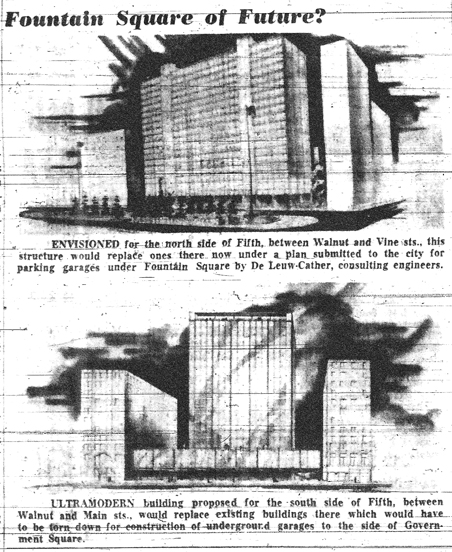
Cincinnati‘s Fountain Square has had a fair share of reinvention over the years.  So too, have the surrounding blocks.  Along with it were many proposals that didn’t quite make the cut. PE recently discovered this plan which we had never seen before.  It proposes development for the “north side of Fifth”, which is now the current home of the aforementioned square and the Tyler-Davidson Fountain itself. 

Also shown is the “ultramodern” (ironically, now an archaic expression) vision for the south side of Fifth between Walnut and Main.  It wasn’t until we had read the caption twice that we realized the bottom rendering is the south side of Government Square and not the south side of Fountain Square. 

The upper photo shows a design that maintains the esplanade that existed as Fountain Square until the late 1960’s.  Instead of this plan the block was demolished and the Fifth Third Center (nee DuBois Tower) was constructed on the eastern and northern sections of the block.  What remained of the block was established as the new Fountain Square and became the current-day showplace for the fountain.

At first glance, the lower photo appears to promote preserving  historic structures as bookends.  Most notable is the handsome Tri-State Building that still stands to this day which appears to be depicted on the right.  However, the caption is explicit and unsurprising.  The plan was to raze the buildings.

Today, the northern half of this block is home to the narrow profile of the Tri-State Building’s northern façade, the Mercantile Center’s Fifth Street entrance and an impenetrable “pocket park” that presumably serves as a buffer for the Federal Reserve Bank Building which occupies the southeastern corner of the block.  It’s unclear from the rendering if the development would have extended south to Fourth Street.

Thankfully, some proposals never come to fruition.  If this particular vision would have been followed, the reconfigured Fountain Square as we know it would likely never have been.

Note: You can get plenty more Unbuilt Cincinnati nuggets at Matt Hunter Ross’ Cincinnati Revisited.

Source: Cincinnati/Kentucky Times-Star


Time Passages…Cincinnati Alleys in 2005

Just for fun, we thought we would haunt some of the alley ways in the Central Business District in 2005. 

Ogden Place - CBD, Cincinnati, OH

Downtown has seen several of these go by the wayside over the years as the CBD demanded that projects be constructed on a large scale. Before superblock developments alleys crossed and subdivided the larger blocks we know today. Today, they’ve been either renamed, obliterated or have become nameless delivery access for the modern towers. Some coincide with present day Skywalk’s. Gone are Egan Alley, Thorp Alley, Hatters Alley and Lawson Alley and others.

A surprising number still survive but without signals or the overhead street signs they have a way of blending into the scenery.  Ogden, Benham, Berning, L’Hommedieu to name a few.  

While nothing special, we did think it would be nice to put them here for you.

Everybody knows this one.  Ogden Place.
Ogden Place - CBD, Cincinnati, OH Ogden Place - CBD, Cincinnati, OH
A new twist?
NURFC - The Banks, Cincinnati, OH

These are unidentified.
Unidentified Alley - CBD, Cincinnati, OH   Unidentified Alley - CBD, Cincinnati, OH

Also, unidentified.
Unidentified Alley - CBD, Cincinnati, OH

Benham Alley.
Benham Alley - CBD, Cincinnati, OH

McFarland Street.  Not an alley but probably one of the lesser known CBD streets.
McFarland Street - CBD, Cincinnati, OH       

And since we know this probably came to mind when you saw the title…you’re welcome!

USquare, University of Cincinnati in 2005

These photos were never really intended for publishing, just for our own documentation purposes here at PE.  We presumed they would provide a nice record of regress/progress in the neighborhood should we have one of our common fits of nostalgia years later.  They do.

EDIT:  With the opening of USquare @ The Loop in August, 2013, these photographs become even more remarkable.
University of Cincinnati, Calhoun & McMillan

Read more of this post